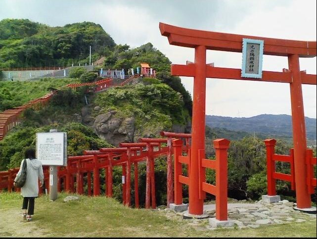
Photo: noppo3 / CC BY-SA 3.0
Japan's Most CM-Famous Scenic Spots
Three Japanese landmarks that went viral through car commercials and CNN: a turquoise bridge, a cliffside torii shrine, and an optical-illusion overpass.
Last updated 2026-08-26
When a Landscape Becomes a Screen Star
Some of Japan's most photographed places did not become famous the old-fashioned way, through centuries of pilgrimage or a mention in classical literature. They became famous because a camera crew found them first. A sweeping bridge over impossibly blue water, a hillside cascading with vermilion shrine gates, and a highway overpass that looks like it was designed for a video game have all become bucket-list stops largely because millions of people saw them on a screen before they ever saw them in person.
This guide covers three such spots in western Japan, all reachable from the Yamaguchi, Shimane, and Tottori area: Tsunoshima Bridge, Motonosumi Inari Shrine, and Eshima Ohashi Bridge. It is worth being precise about how each one actually got famous, because the routes are different. Tsunoshima Bridge and Eshima Ohashi are widely credited to Japanese car commercials that used their dramatic road shapes as a selling point. Motonosumi Inari Shrine's fame is generally traced to an international media list and the social media sharing that followed, not to an advertisement at all. Blurring those origin stories together is easy to do and easy to get wrong, so this article keeps them separate.
Tsunoshima Bridge: The Bridge That Sold Cars
Tsunoshima Bridge (Tsunoshima Ohashi) is a roughly 1,780-meter bridge in Shimonoseki, Yamaguchi Prefecture, connecting the mainland to the small island of Tsunoshima. Opened in 2000 without a toll, it is often cited as one of the longest toll-free bridges in Japan. What makes it a magnet for photographers is the water it crosses: on a sunny day the shallow, sandy-bottomed sea on either side turns a strikingly bright turquoise-to-emerald color, so the bridge appears to float across a tropical-looking lagoon despite being firmly in the Sea of Japan.
The bridge's visibility skyrocketed because of its recurring role in Japanese automobile commercials, and it is widely reported that a Nissan Skyline advertisement was among the campaigns that used its long, gently curving deck as a backdrop, helping cement the bridge's reputation as a dream driving location. Yamaguchi Prefecture's coastal roads more broadly have become a favorite of car-commercial location scouts precisely because of scenery like this, and Tsunoshima Bridge is usually named as the flagship example. Because ad campaigns and their exact vehicle lineups change over the years and are not always centrally documented, treat any specific brand or model attached to the bridge's fame as a reported detail worth double-checking rather than settled trivia, and do not be surprised if you find other car brands and models named in different sources as well.
Whatever the exact commercial history, the practical effect is the same: this is now one of the most Instagrammed bridges in Japan, and it earns that reputation on a clear day when the water color is at its best.
Visiting Tsunoshima Bridge
The classic photo is taken from the Amagase Observation Deck (Amagase Tenboudai), a small parking area and lookout on the mainland side that gives an elevated view down the length of the bridge with the color gradient of the water on full display; it is typically busiest in the late morning through early afternoon when the sun is high enough to light up the turquoise shallows, and many visitors also come for sunset. Tsunoshima Bridge is, however, a real two-lane public road carrying local traffic, delivery vehicles, and cyclists, so pull fully into a designated parking or viewing area before taking photos and never stop in a driving lane or on the shoulder to get a shot. Once across, the island itself has a lighthouse, beaches, and seafood restaurants worth building into a half-day or full-day trip from Shimonoseki, which is roughly a 40 to 50 minute drive away depending on the route.
Motonosumi Inari Shrine: Famous Through a Different Route
Motonosumi Inari Shrine sits on a dramatic stretch of coastline in Nagato, also in Yamaguchi Prefecture, and is instantly recognizable for its row of roughly 123 red torii gates marching down a grassy cliff toward the open ocean, ending with a small offering box mounted unusually high on the final gate. The shrine was founded in the 1950s, which makes it relatively young by Japanese shrine standards, and for decades it remained a fairly local destination.
That changed after CNN Travel included the shrine in a widely shared 2015 feature commonly referenced as "Japan's 31 Most Beautiful Places," which brought it to a global English-speaking audience for the first time. This is the key point that separates Motonosumi from the two bridges in this guide: its rise to fame is generally attributed to that international media coverage and the wave of social media sharing and travel-blog attention that followed, not to a television or car commercial. It is worth being careful not to lump this shrine in with the CM-driven fame of Tsunoshima Bridge or Eshima Ohashi Bridge, since the mechanism by which each place became famous is genuinely different, even though all three now show up in the same social media feeds and the same lists of only-in-Japan photo spots.
Visiting Motonosumi Inari Shrine
The gates run along a sloped path above the cliff edge, and the postcard shot is usually taken partway up the path looking back down the tunnel of red gates toward the ocean, with soft morning light generally considered the most flattering time before midday crowds and haze build up. Near the top of the hill sits a red torii-shaped collection box for the shrine's offerings, itself become something of a photo prop, and a small vermilion Fudekake Inari statue with a fox figure is nearby. Because the path can be narrow and the cliffside footing uneven in places, comfortable shoes are worth wearing, and visitors should stay on the marked path both for their own safety and out of respect for the shrine grounds. The shrine is roughly a 45 minute drive from central Nagato and can reasonably be combined with a Tsunoshima Bridge visit in the same day, since both are on the Yamaguchi coast, though the driving loop between them typically takes a full day when photo stops are included.
Eshima Ohashi Bridge: The Slope That Isn't Quite What It Looks Like
Eshima Ohashi Bridge spans Lake Nakaumi between Matsue in Shimane Prefecture and Sakaiminato in Tottori Prefecture, and it has picked up the nickname "Betabumi-zaka," a colloquial phrase roughly translatable as "floor-it slope," a reference to the idea that a driver would need to floor the accelerator to climb it. The bridge was built tall enough, with a rise of around 44 to 45 meters, to let large ships pass underneath without needing to open, which is what gives it its steep-looking profile in the first place.
Its viral fame is widely credited to a Daihatsu television commercial for the Tanto Custom minivan, which used a long telephoto lens to compress the bridge's approach into what looks like an almost vertical wall of road. The ad prompted a wave of viewers to ask whether such a bridge could possibly be real, and the resulting curiosity, amplified through social media sharing of the commercial and of visitors' own photos, is generally cited as the reason the bridge became a nationally and internationally known photo destination.
The important caveat, confirmed by multiple road tests and measurements after the commercial aired, is that the bridge is nowhere near as steep to actually drive as it appears in that footage. Its real gradient is a modest few percent, comparable to an ordinary highway overpass, and cars cross it at normal speed without any special effort. The dramatic wall-like appearance is a photography trick produced by a long lens compressing perspective from a specific low, distant vantage point, not a description of what driving over the bridge actually feels like, and setting that expectation up front saves visitors from disappointment or confusion when they arrive and find a perfectly ordinary-feeling drive.
Visiting Eshima Ohashi Bridge and Practical Notes for All Three Spots
The famous compressed-perspective photo of Eshima Ohashi is typically taken from a distance on the Shimane side, using a zoom or telephoto lens from a low angle near the water rather than from on top of the bridge itself, and there are informal viewing spots near the shoreline on both approaches where photographers commonly set up; a clear day with good visibility generally produces the most striking compression effect. As with Tsunoshima Bridge, this is a functioning stretch of national highway carrying regular commuter and freight traffic, so photograph it from the roadside or an official pull-off, never from a traffic lane or the bridge deck itself, and be mindful of local residents who use this bridge every day as part of ordinary life rather than as a backdrop.
All three locations reward a rental car more than public transit, since they sit in the less densely served parts of Yamaguchi, Shimane, and Tottori; Shimonoseki and Nagato serve as reasonable bases for Tsunoshima Bridge and Motonosumi Inari Shrine, while Matsue or Yonago make sensible bases for Eshima Ohashi Bridge, and driving between the two clusters typically takes a couple of hours along the San'in coast. None of these sites charge admission, and none keep fixed hours in the way a museum would, though visiting in daylight is strongly recommended for both photography and safety. Because opening arrangements, parking rules, and even nicknames tied to advertising campaigns can shift over time, it is worth checking current local tourism information before a trip, and treating any single ad campaign or brand mentioned here as the commonly reported version of the story rather than an unchangeable fact.
Related reading
Want a full itinerary, not just one article?
The Trip Planner builds a day-by-day plan around the regions and interests you pick.
Open Trip Planner